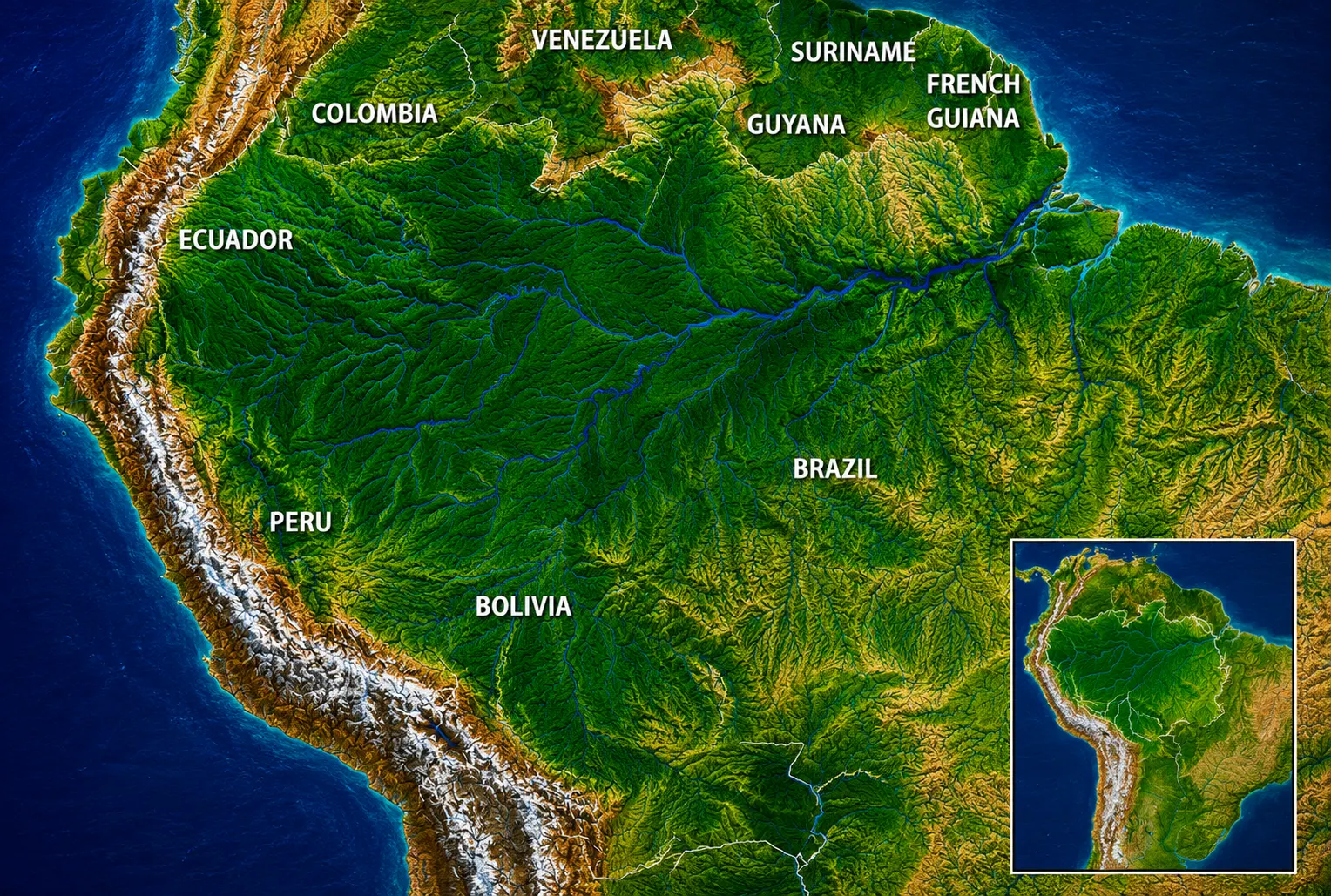
The Amazon Rainforest is located in South America, covering a vast area of the Amazon Basin across several countries. Most of the rainforest lies in Brazil, but the Amazon also extends into Peru, Colombia, Bolivia, Ecuador, Venezuela, Guyana, Suriname, and French Guiana. It is not a single forest contained within one national border. Instead, the Amazon is a massive tropical rainforest ecosystem connected by thousands of rivers, wetlands, forests, and tributaries throughout the Amazon Basin.
The easiest way to understand where the Amazon Rainforest is located is to look at its position relative to the Amazon River and the surrounding countries. The forest stretches from the eastern slopes of the Andes in western South America toward the Atlantic Ocean in the east. Its enormous geographic range includes areas north and south of the Equator, although much of the basin lies within the tropics.
The Amazon is remarkable not only because of its size, but also because of its geographic complexity. Different parts of the rainforest have different landscapes, climates, rivers, wildlife, and human cultures. Understanding its location therefore requires looking at the Amazon Basin, the countries it crosses, its major rivers, and its position on a map.
Where Is the Amazon Rainforest Located?
The Amazon Rainforest is located in northern South America, primarily within the enormous Amazon Basin. It occupies much of Brazil and extends westward toward the Andes, with additional rainforest areas in Peru, Colombia, Bolivia, Ecuador, Venezuela, Guyana, Suriname, and French Guiana.
The forest lies roughly between the Andes Mountains in the west and the Atlantic Ocean in the east. The Amazon River and its extensive network of tributaries form the central drainage system of this geographic region. Because the basin is so large, the rainforest covers an area comparable to several large countries combined.
The location of the Amazon is strongly influenced by its tropical position. Warm temperatures, abundant rainfall, and extensive river systems create conditions that support dense forests and exceptionally high biological diversity.
Location in South America
On a map of South America, the Amazon Rainforest occupies much of the northern and central portion of the continent. Its largest continuous areas are in Brazil, while substantial sections occur in western and northwestern South America.
The rainforest extends across both sides of the Equator. However, the Equator does not divide the Amazon into two equal halves. Large portions of the forest are south of the Equator, particularly in Brazil, while major areas also occur north of it in countries such as Colombia, Venezuela, Guyana, and Suriname.
Its position gives the Amazon a distinctive geographic relationship with several major South American features:
- The Andes Mountains form much of its western boundary.
- The Atlantic Ocean lies to the east.
- The Guiana Shield occupies important areas to the north.
- The Brazilian Highlands influence portions of the southern basin.
- The Amazon River crosses the basin from west to east.
- Thousands of tributaries connect different regions of the forest.
The Amazon Basin
The Amazon Basin is much larger than the area occupied by rainforest alone. It is the enormous drainage basin through which the Amazon River and its tributaries collect water.
This distinction is important when asking where the Amazon Rainforest is located. The rainforest is the forest ecosystem, while the Amazon Basin is the broader geographic and hydrological region surrounding the river system.
The basin covers millions of square kilometers and includes forests, rivers, floodplains, wetlands, savannas, mountains, and areas that have been modified by human activity.
Water is one of the defining characteristics of the region. During the rainy season, rivers can expand dramatically and flood large areas of forest. Some trees are adapted to remain underwater for extended periods, creating specialized ecosystems known as flooded forests.
Geographic Region of the Amazon
Geographically, the Amazon is part of the tropical region of South America. Its climate is predominantly hot and humid, although conditions vary considerably across such a large area.
The western Amazon is particularly influenced by the Andes. Rivers originating in the mountains carry enormous quantities of sediment into the lowlands. In contrast, parts of the eastern Amazon are closer to the Atlantic and have different geological and ecological characteristics.
The Amazon should therefore be viewed as a continent-scale ecological region rather than a single uniform forest.
Where Is the Amazon Rainforest on a Map?
If you look at an Amazon Rainforest map, the forest appears as a huge green region occupying much of northern South America. The largest portion is in Brazil, but the green belt continues across national boundaries into several neighboring countries.
A useful way to locate it on a map is to first find the Amazon River. Follow the river westward from its enormous mouth on Brazil’s Atlantic coast toward the Andes. Much of the surrounding lowland region forms part of the Amazon Basin and contains Amazon rainforest.
The forest is not perfectly circular or rectangular. Its boundaries change depending on whether a map shows the ecological rainforest, the broader Amazon Basin, or areas classified according to vegetation and land cover.
Main Regions and Rivers
The Amazon’s geography is closely connected to its rivers. The Amazon River is the principal river system, but it is joined by an enormous network of tributaries.
Some of the best-known rivers associated with the Amazon include:
- Amazon River
- Rio Negro
- Madeira River
- Tapajós River
- Xingu River
- Purus River
- Juruá River
- Japurá River
- Marañón River
- Ucayali River
- Napo River
These rivers are more than geographic features. They provide transportation routes, shape habitats, influence seasonal flooding, and support communities throughout the rainforest.
One of the most unusual features of the Amazon is the Meeting of the Waters, where the dark waters of the Rio Negro flow alongside the muddy, sediment-rich waters of the Solimões River near Manaus before eventually mixing downstream. Differences in temperature, sediment, speed, and water chemistry can keep the two waters visibly separated for several kilometers.
Where Is the Amazon River Compared With the Rainforest?
The Amazon River runs through the heart of the broader Amazon region, but the rainforest extends far beyond the river itself. Millions of smaller streams and tributaries penetrate the forest.
The river system essentially acts as the Amazon’s geographic skeleton. Major tributaries reach deep into the forest, creating corridors through otherwise difficult terrain.
This is why an Amazon map showing only the Amazon River provides an incomplete picture of where the Amazon Rainforest is located.
Which Countries Is the Amazon Rainforest In?
The Amazon Rainforest extends across eight countries and one overseas territory. Brazil contains by far the largest portion, followed by Peru and Colombia in terms of the extent of Amazonian territory.
The countries and territory associated with the Amazon are:
- Brazil
- Peru
- Colombia
- Bolivia
- Ecuador
- Venezuela
- Guyana
- Suriname
- French Guiana
French Guiana is not an independent country; it is an overseas department and region of France. Together, these territories form the broader geographic range commonly associated with the Amazon.
Amazon Rainforest in Brazil
Brazil contains the largest share of the Amazon Rainforest, making Brazil the country most strongly associated with the Amazon.
The Brazilian Amazon occupies a huge portion of northern Brazil. Important Amazonian states include Amazonas, Pará, Acre, Rondônia, Roraima, Amapá, and parts of Maranhão and Mato Grosso.
The city of Manaus is one of the most important urban centers within the Brazilian Amazon. Located near the meeting of the Rio Negro and Solimões River, Manaus serves as a major gateway to the surrounding rainforest.
The Brazilian portion contains some of the Amazon’s most famous landscapes, rivers, protected areas, and wildlife habitats. It also includes extensive areas affected by agriculture, roads, mining, logging, and other forms of development.
When people search “where is the Amazon rainforest in Brazil?”, the simplest answer is: primarily across northern Brazil, especially throughout the vast Amazon Basin.
Amazon Rainforest in Peru
The Peruvian Amazon occupies the eastern lowlands of Peru, extending from the foothills of the Andes into the Amazon Basin.
This region is especially interesting because Peru contains areas where the Andes and Amazon meet. Rivers descend from the mountains into the lowland rainforest, creating highly diverse landscapes.
Important Amazonian areas of Peru include the regions around Loreto, Ucayali, Madre de Dios, San Martín, Amazonas, and parts of Huánuco, Pasco, Junín, and Cusco.
Cities such as Iquitos and Puerto Maldonado are closely associated with the Peruvian rainforest. Iquitos is particularly unusual because it is a major city that has no direct road connection to the rest of Peru and is instead connected by air and river transportation.
Peru’s Amazon is also known for extensive protected forests and extraordinary wildlife diversity.
Amazon Rainforest in Colombia
The Colombian Amazon lies primarily in the southeastern part of the country. It includes departments such as Amazonas, Caquetá, Guaviare, Guainía, Putumayo, and Vaupés.
The Colombian Amazon occupies an important transition between the Andes, lowland rainforest, and other ecosystems. The region contains enormous stretches of relatively remote forest.
The city of Leticia, located near the borders of Colombia, Peru, and Brazil, is one of the best-known gateways to the Colombian Amazon.
The Colombian portion is particularly important for Indigenous cultures and river-based communities. The region also contains extensive protected areas and habitats for species such as pink river dolphins, monkeys, macaws, jaguars, giant river otters, and countless insects.
Amazon Rainforest in Ecuador
The Ecuadorian Amazon, often called the Ecuadorian Oriente, occupies the eastern portion of Ecuador beyond the Andes.
Although Ecuador is much smaller than Brazil, its Amazonian region contains remarkably diverse rainforest habitats. The transition from the Andes to the Amazon creates substantial changes in elevation, climate, vegetation, and wildlife over relatively short distances.
Important Amazonian provinces include Sucumbíos, Orellana, Napo, Pastaza, Morona Santiago, and Zamora-Chinchipe.
Ecuador’s Amazon is home to famous protected areas and exceptionally biodiverse landscapes. Yasuni National Park, for example, is internationally recognized for its extraordinary biological richness.
The Ecuadorian Amazon demonstrates why the Amazon cannot be understood simply as one enormous lowland forest. Its western margins interact directly with the Andes, producing some of the most complex ecological gradients in South America.
Amazon Rainforest in Bolivia
The Bolivian Amazon covers much of northern Bolivia, particularly areas within the departments of Pando, Beni, and parts of La Paz, Cochabamba, and Santa Cruz.
Bolivia’s Amazon includes extensive lowland forests, rivers, wetlands, and seasonally flooded landscapes. It is particularly important for wildlife such as jaguars, river dolphins, giant otters, monkeys, macaws, and numerous fish species.
The northern lowlands are less densely populated than many other parts of Bolivia, allowing large areas of forest to remain relatively remote.
Amazon Rainforest in Venezuela
The Venezuelan Amazon is concentrated primarily in the southern part of Venezuela, particularly in the state of Amazonas and adjacent areas.
This region contains extensive rainforest and dramatic geological formations associated with the Guiana Shield. It is also home to large rivers and isolated landscapes.
Venezuela’s Amazon is particularly notable for its tepuis—ancient, flat-topped mountains that rise dramatically above the surrounding landscape. These formations support unusual ecosystems and species found nowhere else.
Amazon Rainforest in Guyana and Suriname
The forests of Guyana and Suriname form part of the northeastern Amazon region. Both countries retain extensive forest cover, particularly in their interiors.
These areas are important examples of relatively intact tropical forest landscapes. Low population density across large interior areas has helped maintain substantial forest ecosystems.
Guyana’s interior includes major rivers and large protected landscapes, while Suriname has one of the world’s highest proportions of forest cover.
Amazon Rainforest in French Guiana
French Guiana contains extensive tropical rainforest and forms the northeastern edge of the Amazonian region.
Because French Guiana is part of France, the Amazon here is technically within French territory. The landscape includes dense forests, rivers, protected areas, and relatively low population density away from the coastal zone.
This makes French Guiana an interesting geographical exception when answering the question “What country is the Amazon Forest in?” The Amazon is not confined to independent South American nations.
What Country Is the Amazon Forest In?
There is no single answer to “Amazon forest in which country?” because the Amazon Rainforest crosses international borders.
Brazil contains the largest portion, but the rainforest also extends through Peru, Colombia, Bolivia, Ecuador, Venezuela, Guyana, Suriname, and French Guiana.
A simplified ranking by the approximate share of the Amazon ecosystem within each territory places Brazil clearly first, followed by Peru and Colombia. However, the exact percentages depend on how the Amazon is defined. A map of the Amazon Basin, for example, does not show exactly the same boundaries as a map of Amazon rainforest vegetation.
This is an important distinction when comparing maps and statistics about the region.
Why Is the Amazon Rainforest Located There?
The Amazon exists where it does because of a combination of latitude, climate, mountains, atmospheric circulation, and river geography.
The region receives enormous quantities of moisture. Water evaporates from vegetation, rivers, soil, and the Atlantic Ocean, while rainfall returns much of that moisture to the forest.
The Andes and the Amazon
The Andes Mountains play a critical role in the Amazon’s geography. Moisture-laden air moves westward from the Atlantic and across the Amazon Basin. When it encounters the Andes, the mountains influence rainfall and atmospheric circulation.
The Andes also supply enormous quantities of water and sediment to Amazonian rivers.
Tropical Climate
Much of the Amazon lies within the tropics, where temperatures remain relatively high throughout the year.
Rainfall patterns vary from place to place, but the combination of heat and abundant precipitation supports dense forests.
The rainforest itself also influences the climate. Trees release water vapor through transpiration, contributing to atmospheric moisture and helping sustain rainfall across the region.
Is the Entire Amazon Rainforest the Same?
No. The Amazon contains numerous distinct ecosystems.
Terra Firme Forest
Terra firme forests grow on land that generally does not experience regular seasonal flooding. These forests contain some of the most recognizable characteristics of the Amazon, including extremely tall trees and multiple layers of vegetation.
Flooded Forests
Some Amazon forests are periodically flooded by rivers. These environments are commonly divided into different types depending on the source and characteristics of the water.
Flood-adapted trees can survive conditions that would kill many plants elsewhere.
Várzea and Igapó
Várzea forests are generally associated with nutrient-rich floodwaters carrying sediment, while igapó forests are associated with blackwater or other relatively nutrient-poor waters.
These differences in water chemistry create different plant communities and ecological conditions.
River Islands and Wetlands
The Amazon also contains countless river islands, lakes, channels, marshes, and seasonally inundated areas.
As rivers shift their channels over time, they continuously reshape the landscape.
Interesting Facts About the Location of the Amazon Rainforest
1. The Amazon Crosses the Equator
The Equator passes through the Amazon region, but the rainforest is not located entirely on one side of it.
This means that parts of the Amazon experience seasonal patterns influenced by both northern and southern hemisphere climate cycles.
2. Brazil Does Not Contain the Entire Amazon
Because Brazil has the largest share, it is easy to assume that the Amazon is exclusively Brazilian. It is not.
The rainforest is a multinational ecosystem spanning much of northern South America.
3. The Amazon River Flows Toward the Atlantic
The Amazon River ultimately drains into the Atlantic Ocean.
Its enormous discharge makes it one of the most significant river systems on Earth.
4. The Amazon Has No Simple Border
Unlike a national park, the rainforest does not have a single universally agreed boundary.
Scientists and organizations may use different definitions based on vegetation, climate, drainage basins, ecological characteristics, or political geography.
5. The Amazon Contains Both Mountains and Lowlands
The phrase “Amazon Rainforest” often evokes flat jungle, but the wider Amazon region includes dramatic elevation changes.
The western edge rises toward the Andes, while much of the central basin consists of lowland terrain.
6. Some Amazon Trees Spend Months Underwater
In floodplain forests, seasonal flooding can leave trees partially or almost completely submerged.
Some species have evolved remarkable adaptations that allow them to survive these conditions.
7. The Forest Creates Part of Its Own Rainfall
Amazon vegetation continuously releases water vapor into the atmosphere.
This creates a powerful feedback system in which forests contribute to atmospheric moisture that can later return as rainfall.
8. Rivers Are Natural Highways
In many remote Amazonian areas, rivers remain among the most practical transportation routes.
Communities can be separated by enormous distances and dense vegetation, making river travel essential.
9. The Amazon Is Larger Than a Single Ecosystem
The word “Amazon” can refer to several different geographic concepts:
- Amazon Rainforest
- Amazon Basin
- Amazon River
- Amazon biome
- Amazon region
- Pan-Amazonian region
These terms overlap, but they are not interchangeable.
What Is Unusual About the Amazon’s Geography?
One of the most unusual characteristics of the Amazon is the way forest, water, and atmosphere interact on an enormous scale.
In some areas, the boundary between land and river changes dramatically during the year. Forests that appear to be located on dry land during one season may become flooded during another.
Another unusual feature is the enormous number of rivers and streams. Rather than being a forest with a few major waterways, the Amazon is a landscape deeply penetrated by water.
The western Amazon is also geographically extraordinary because the lowland rainforest begins relatively close to the towering Andes. This creates an ecological gradient from high-elevation mountain environments through foothill forests and eventually into lowland rainforest.
The Amazon Rainforest Today
The Amazon remains one of the world’s most important tropical ecosystems, but its geography is changing because of deforestation, forest degradation, fires, infrastructure development, mining, agriculture, and climate-related pressures.
The situation is not identical in every country or region. Some areas have extensive protected forests and relatively intact ecosystems, while other areas have experienced substantial forest loss.
A particularly important distinction is between deforestation and degradation. Deforestation involves the conversion of forest to another land use, while degradation can damage forests without completely removing the tree cover. Logging, repeated fires, drought, and fragmentation can all degrade forests.
Climate change also creates additional pressure through changes in temperature, rainfall patterns, drought frequency, and fire conditions.
Why the Amazon’s Location Matters
The Amazon’s enormous geographic scale means that changes in one part of the system can have consequences beyond local boundaries.
The forest influences:
- Regional rainfall
- River systems
- Carbon storage
- Biodiversity
- Local and regional climate
- Soil and nutrient cycles
- Indigenous livelihoods
- Agriculture and water resources
Its location also makes it an important link between the Andes, the interior of South America, and the Atlantic Ocean.
A Simple Way to Find the Amazon on a Map
If you want to identify where the Amazon Rainforest is located on a map, follow these steps:
- Find South America.
- Locate Brazil in the eastern and central part of the continent.
- Find the Amazon River, which crosses northern Brazil toward the Atlantic.
- Look west toward Peru, Colombia, and the Andes Mountains.
- Extend the rainforest region north toward Venezuela, Guyana, and Suriname.
- Include Bolivia and Ecuador to the south and west.
- Remember that French Guiana forms part of the Amazon region in the northeast.
This provides a simple geographic overview, although the precise boundaries depend on which definition of the Amazon is being used.
Where Is the Amazon Rainforest? Quick Answer
The Amazon Rainforest is in South America, primarily within Brazil and the Amazon Basin. It stretches from the eastern slopes of the Andes to the Atlantic Ocean and crosses Brazil, Peru, Colombia, Bolivia, Ecuador, Venezuela, Guyana, Suriname, and French Guiana.
Brazil contains the largest share of the rainforest, while Peru and Colombia also contain enormous Amazonian regions.
The Amazon is therefore best understood not as a forest belonging to one country, but as a vast transnational tropical ecosystem centered on the Amazon Basin.
Frequently Asked Questions About the Amazon Rainforest
Where is the Amazon Rainforest located?
The Amazon Rainforest is located in northern South America, mainly within the Amazon Basin. It extends from the Andes in the west toward the Atlantic Ocean in the east and crosses several South American countries.
Where is the Amazon Rainforest on a map?
On a map, the Amazon appears as a large tropical forest region covering much of northern and central South America. Its largest portion is in Brazil, with major extensions into Peru, Colombia, Bolivia, Ecuador, Venezuela, Guyana, Suriname, and French Guiana.
What country is the Amazon Rainforest in?
The Amazon Rainforest is not in only one country. Brazil contains the largest portion, but the rainforest extends into eight independent countries and French Guiana.
Where is the Amazon Rainforest in Brazil?
The Brazilian Amazon is primarily in northern Brazil. It includes extensive areas of Amazonas, Pará, Acre, Rondônia, Roraima, Amapá, and parts of other states.
Where is the Amazon Rainforest in Peru?
The Peruvian Amazon lies east of the Andes and covers much of eastern Peru. Major Amazonian regions include Loreto, Ucayali, and Madre de Dios, among others.
Where is the Amazon Rainforest in Colombia?
The Colombian Amazon is located mainly in southeastern Colombia. Major Amazonian departments include Amazonas, Caquetá, Guaviare, Guainía, Putumayo, and Vaupés.
Where is the Amazon Rainforest in Ecuador?
The Ecuadorian Amazon is in eastern Ecuador on the eastern side of the Andes. It includes provinces such as Napo, Orellana, Pastaza, and Sucumbíos.
Is the Amazon Rainforest near the Equator?
Yes. The Equator crosses the Amazon region. However, the rainforest extends both north and south of the Equator.
Is the Amazon Rainforest the same as the Amazon Basin?
No. The Amazon Basin is the enormous drainage basin associated with the Amazon River and its tributaries. The Amazon Rainforest is the tropical forest ecosystem occupying much of that basin, although the two areas do not have identical boundaries.
Is the Amazon Rainforest only jungle?
No. The Amazon contains many different environments, including terra firme forests, flooded forests, wetlands, rivers, lakes, savannas, river islands, and areas influenced by the Andes.
Why is the Amazon Rainforest so wet?
Its tropical location, proximity to the Atlantic, enormous river system, and constant recycling of water through vegetation all contribute to its humid climate and abundant rainfall.
Final Answer: Where Is the Amazon Rainforest?
The Amazon Rainforest is located in South America, primarily across the enormous Amazon Basin. Most of it is in Brazil, but it also extends through Peru, Colombia, Bolivia, Ecuador, Venezuela, Guyana, Suriname, and French Guiana.
Geographically, the Amazon stretches from the Andes Mountains in the west to the Atlantic Ocean in the east and occupies a vast area around the Amazon River and its tributaries. The Equator crosses the region, while thousands of rivers, floodplains, wetlands, and different forest types make the Amazon far more geographically diverse than a simple map of “the jungle” suggests.
Its unusual scale, interconnected river systems, extraordinary biodiversity, and influence on rainfall make the Amazon one of the most important geographic and ecological regions on Earth. Understanding where the Amazon Rainforest is located therefore means looking beyond Brazil alone and recognizing the Amazon as a vast, interconnected landscape shared across much of northern South America.