The Amazon River is one of the most remarkable rivers on Earth. It crosses the heart of South America, carries an extraordinary volume of freshwater toward the Atlantic Ocean, drains one of the world’s largest river basins, and supports an immense variety of aquatic and terrestrial life. Understanding the Amazon requires looking at much more than its length: its source, tributaries, width, depth, seasonal flooding, geographic location, and relationship with the surrounding rainforest all help explain why this river is so extraordinary.
For travelers, researchers, students, and anyone interested in geography, some of the most common questions are How long is the Amazon River? Where is the Amazon River? What country is the Amazon River in? Where does it start? Where does it end? How wide is the Amazon River? And how deep is the Amazon River? There is also a long-standing geographical question: Is the Amazon River the longest river in the world?
The answers are more interesting than a single number. The Amazon is a constantly changing river system whose dimensions vary depending on location, season, water level, and the definition used to identify its most distant source.
Amazon River Facts
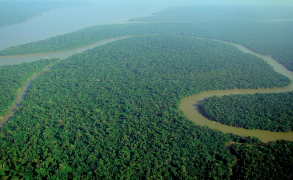
The Amazon River is the principal river of the Amazon Basin and one of the world’s great freshwater systems. Its main channel and enormous network of tributaries connect the Andes with the Atlantic Ocean. The river’s watershed covers a vast portion of South America and extends across several countries, while the main Amazon channel flows primarily through Peru, Colombia, and Brazil.
The river is especially remarkable for its enormous discharge. More water flows through the Amazon system toward the Atlantic than through any other river system, making its freshwater contribution to the ocean one of its defining characteristics. During the rainy season, water levels can rise dramatically, transforming large areas of surrounding forest into seasonally flooded habitat.
The Amazon is also unusual because it does not have a single universally uncontested starting point. Different studies and geographic definitions can identify different headwaters as the river’s most distant source, which affects calculations of its total length.
10 Facts About the Amazon River
- The Amazon is one of the world’s largest rivers. Its enormous discharge makes it the largest river by volume of water discharged into the ocean.
- The river crosses several South American countries. The main river passes through or forms borders involving Peru, Colombia, and Brazil.
- Its basin is much larger than the main river itself. Thousands of tributaries contribute water to the Amazon system.
- The river begins in the Andes region. Its headwaters originate in high-elevation environments before descending toward the lowland rainforest.
- The Amazon ends in the Atlantic Ocean. Its enormous mouth opens into the Atlantic on the northeastern coast of Brazil.
- Its width changes dramatically. The river can be relatively narrow in some areas and expand enormously during seasonal flooding.
- Its depth also varies. Water levels and depths change according to location, river morphology, and seasonal rainfall.
- The Amazon is closely connected to rainforest ecology. Seasonal flooding creates habitats used by fish, birds, reptiles, mammals, and plants.
- Its length is debated. Different definitions of the river’s source can produce different measurements.
- The Amazon is a living, changing system. Its channels, floodplains, islands, sandbars, and wetlands change as water levels rise and fall.
How Long Is the Amazon River?
The question “How long is the Amazon River?” does not have one universally accepted answer because measuring the length of a river depends on identifying exactly where the river begins.
The commonly cited length of the Amazon is approximately 6,400 kilometers (about 4,000 miles), although measurements can differ. The principal reason for these differences is the identification of the river’s most distant headwater.
A river does not begin as a single enormous channel. It develops through a network of small streams, springs, mountain waterways, and tributaries. Determining which one represents the true beginning of the main river can therefore be surprisingly complicated.
Amazon River Length
When discussing Amazon River length, it is important to distinguish between the length of the main recognized river course and measurements that trace the river system to its most distant possible headwater.
Why can measurements be different?
Several factors influence the calculation:
- Which headwater is considered the source
- Whether the measurement follows the main channel or a particular tributary
- How bends and curves are measured
- Changes in river channels over time
- Seasonal water conditions
- Improvements in geographic mapping technology
This is why one source may give a slightly different number from another without either measurement necessarily being meaningless.
Amazon River Length Compared With Other Major Rivers
The Amazon is frequently compared with the Nile because of the question of which is the longest river on Earth.
The comparison becomes complicated because both rivers have extensive networks of tributaries and multiple possible definitions of their sources. Small changes in the identified starting point can substantially affect the total distance.
For this reason, the question of river length should be understood as a geographic measurement issue rather than simply a competition between two numbers.
Is the Amazon River the Longest River in the World?
The question “Is the Amazon River the longest river in the world?” has generated considerable geographical debate.
The traditional widely used ranking has often placed the Nile first by length, with the Amazon close behind. However, some measurements and studies have argued that when a more distant Amazonian headwater is considered, the Amazon can rival or exceed the Nile.
The disagreement exists because determining the precise source of a giant river system is difficult.
Why the Longest-River Question Is Complicated
A river’s length is not measured simply from the point where a large visible channel appears.
Instead, researchers need to determine which stream represents the most distant continuous source and how that source connects to the main river.
For a river as enormous as the Amazon, its headwaters include numerous mountain streams and tributaries.
Length is not the same as size
Even if the exact length remains debated, there is much less ambiguity about the Amazon’s extraordinary size in other measurements.
The Amazon is widely recognized for:
- Enormous water discharge
- Huge drainage basin
- Vast network of tributaries
- Exceptional freshwater contribution
- Extensive floodplains
- Major ecological importance
Therefore, the Amazon does not need to be declared the longest river to be one of the most geographically significant rivers on Earth.
Where Is the Amazon River?
The Amazon River is located in South America, flowing generally eastward from the Andes toward the Atlantic Ocean.
Its course passes through some of the world’s most extensive tropical rainforest landscapes. The river’s main channel and tributaries create a massive interconnected water network extending across much of the Amazon Basin.
The river begins in the western part of the continent and ultimately reaches the Atlantic Ocean in northern Brazil.
Amazon River in Which Country?
A common question is “Amazon River in which country?”
The answer is that the Amazon River is not located entirely within a single country.
The main river is associated particularly with Peru, Colombia, and Brazil.
Its broader drainage basin extends into additional South American countries, including:
- Bolivia
- Ecuador
- Peru
- Colombia
- Brazil
- Venezuela
- Guyana
- Suriname
- French Guiana
It is important to distinguish the Amazon River from the Amazon Basin. The main river follows a specific course, while the basin encompasses the enormous area from which water drains into the Amazon river system.
Which Countries Does the Amazon River Flow Through?
The principal course of the Amazon is generally described as flowing through Peru, Colombia, and Brazil.
Peru
The Amazon system begins in the Andes of Peru, where high-elevation rivers descend toward the lowland rainforest.
Peru is therefore extremely important when discussing the Amazon River source.
The Peruvian Amazon also contains major tributaries and extensive rainforest landscapes.
Colombia
The Amazon River reaches Colombia near the country’s southern Amazon region. The city of Leticia is located on the Amazon River and is an important gateway to the surrounding rainforest.
The river also forms part of the geographical landscape connecting Colombia with Peru and Brazil.
Brazil
Brazil contains the greatest portion of the main lowland Amazon River system. The river travels thousands of kilometers through the Brazilian Amazon before reaching the Atlantic.
Major tributaries join the river along its course, dramatically increasing its volume.
The Amazon Basin is larger than the river’s main route
Although only several countries are directly associated with the principal river channel, the Amazon Basin extends across a much broader area.
This distinction is essential when discussing Amazon geography.
Amazon River Map
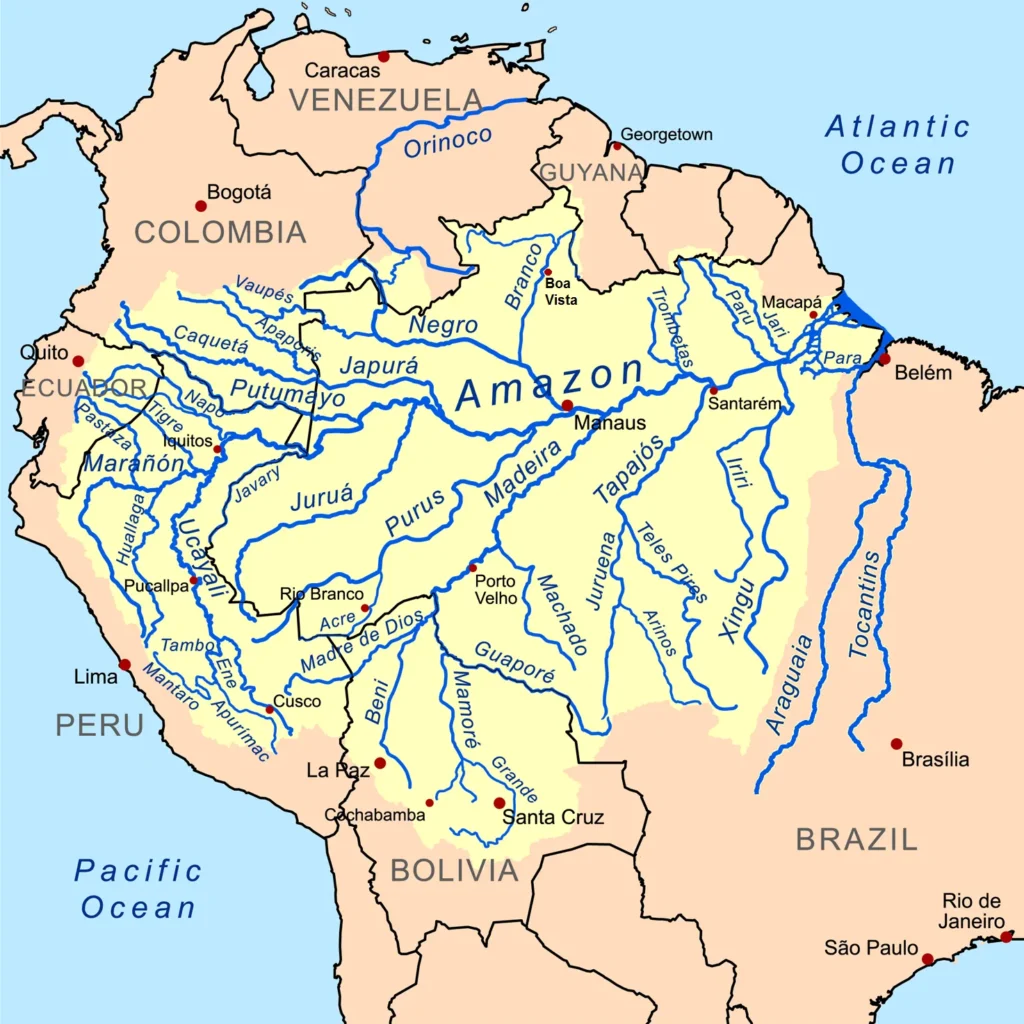
An Amazon River map shows one of the most impressive geographic patterns in South America: a vast network of waterways extending from the Andes across the continent toward the Atlantic.
The river’s general route can be simplified into three major geographical stages:
Andes → Western Amazon → Eastern Amazon → Atlantic Ocean
A detailed map should ideally show:
- Amazon River source
- Main river channel
- Major tributaries
- Peru
- Colombia
- Brazil
- Major Amazonian cities
- Atlantic Ocean
- Major headwaters
- Amazon Basin
Major Tributaries of the Amazon
The Amazon’s extraordinary size is partly explained by the enormous number of tributaries that feed it.
Important tributaries include:
- Rio Negro
- Madeira River
- Japurá River
- Purus River
- Juruá River
- Tapajós River
- Xingu River
- Marañón River
- Ucayali River
These tributaries contribute huge quantities of water and create additional aquatic habitats.
The Meeting of Waters
One of the most unusual visual phenomena associated with the Amazon system occurs near Manaus, where the dark waters of the Rio Negro meet the sediment-rich waters of the Solimões.
The two water masses can flow beside each other for several kilometers before becoming fully mixed.
This happens because they have different temperatures, speeds, densities, and sediment characteristics.
Where Does the Amazon River Start?
The answer to “Where does the Amazon River start?” depends on how the river’s source is defined.
The Amazon’s headwaters are located in the Andes of Peru.
Several rivers and tributaries contribute to the developing Amazon system, particularly the Marañón and Ucayali systems.
Farther upstream are smaller mountain streams that eventually combine into larger waterways.
Amazon River Source
The Amazon River source is one of the most interesting geographical questions surrounding the river.
Unlike a river that begins at a clearly identifiable spring, the Amazon develops from an extensive network of high-altitude waterways.
Researchers have investigated different Peruvian headwaters as candidates for the most distant source.
The debate has important consequences because identifying a source farther upstream automatically increases the measured length of the river.
Where Is the Source of the Amazon River?
The source of the Amazon is associated with the Peruvian Andes.
The upper river system contains cold mountain streams, steep valleys, and high-altitude landscapes that are dramatically different from the hot, humid lowland rainforest.
As water moves downhill, tributaries merge and the river becomes increasingly large.
This creates an extraordinary geographical transition:
High Andes → Mountain valleys → Foothills → Lowland rainforest → Massive river → Atlantic Ocean
The Amazon therefore connects some of the highest landscapes in western South America with the world’s largest tropical rainforest region.
Why Is the Source of the Amazon River Debated?
The question “Why is the source of the Amazon River debated?” has a simple underlying explanation: the Amazon has many headwaters.
A river’s source can be defined in different ways.
One approach is to identify the stream that is farthest from the mouth. Another may consider the longest continuous channel, greatest water contribution, or another geographical characteristic.
The Role of Remote Mountain Streams
Some candidate headwaters are located in remote Andean environments.
They may appear small compared with the enormous Amazon River thousands of kilometers downstream.
Yet if one of these tiny streams can be traced continuously into the larger river system, it can potentially become important when calculating total river length.
An unusual fact about the Amazon
A tiny mountain stream in Peru can ultimately contribute water to one of the largest river systems on Earth.
This enormous transformation—from a narrow high-altitude stream to a gigantic tropical river—is one of the most fascinating aspects of Amazon geography.
How Wide Is the Amazon River?
The question “How wide is the Amazon River?” has no single answer.
The Amazon changes dramatically in width along its course.
In some locations, the main channel is relatively confined. In other areas, particularly during high-water periods, the river and its interconnected floodplain can extend across enormous distances.
Amazon River Width
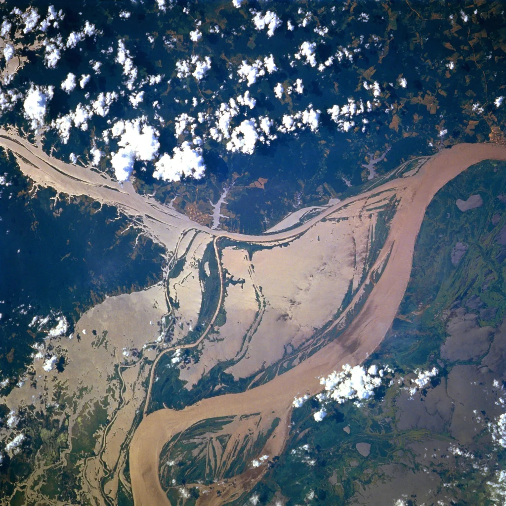
The width depends on several factors:
- Location
- River channel shape
- Season
- Water level
- Tributaries
- Floodplain connections
- Islands
- Sandbars
- Local geography
During the dry season, certain channels may become considerably narrower as water levels fall.
During high water, the river can expand into surrounding forests and floodplain lakes.
Main channel versus flooded landscape
An important distinction must be made between the width of the main river channel and the total area covered by water during flooding.
When seasonal water levels rise, the Amazon can connect with surrounding channels, lakes, and flooded forests.
This can make the entire aquatic landscape appear dramatically wider than the permanent river channel itself.
Why Does the Amazon River Change Width?
The Amazon changes width because it is a dynamic river system strongly influenced by seasonal rainfall.
During periods of high rainfall in the Andes and Amazon Basin, enormous quantities of water enter the river network.
Water levels rise and spread across floodplains.
During lower-water periods, the river contracts, exposing sandbars, beaches, islands, and sections of riverbank that may be submerged months earlier.
Seasonal Flooding
Seasonal flooding is essential to the Amazon ecosystem.
Rather than being simply a problem for wildlife, annual water-level changes create habitats and transport nutrients throughout the floodplain.
Fish may enter flooded forests to feed.
Birds exploit new feeding areas.
Plants tolerate prolonged periods of inundation.
Local communities adapt their activities and transportation to changing water levels.
How Deep Is the Amazon River?
How deep is the Amazon River? is another question without one universal number.
The depth varies according to location, season, river morphology, sedimentation, and water level.
Some sections are relatively shallow, while deep channels can reach many meters below the water surface.
Amazon River Depth
Depth is influenced by:
- Channel shape
- Water volume
- Seasonal flooding
- Sediment movement
- Local geology
- Tributary contributions
- River bends
- Islands and submerged formations
A measurement taken in one section of the Amazon should therefore not be treated as representative of the entire river.
Does the Amazon River Get Deeper During the Rainy Season?
Generally, water levels and navigable depths increase during periods of high water, although the exact change depends on location.
Heavy rainfall in the river’s enormous drainage basin contributes to rising water levels.
The effect can take time because water must travel through thousands of kilometers of tributaries before reaching particular sections of the main river.
During high-water periods, waterways that are too shallow or disconnected during the dry season can become navigable.
The Amazon River and Seasonal Flooding
One of the Amazon’s most important natural processes is its annual cycle of rising and falling water.
The flood pulse affects almost every part of the surrounding ecosystem.
Flooded Forests
Some Amazon forests are adapted to spending part of the year underwater.
These areas are sometimes called floodplain forests.
Trees in these environments have adaptations that allow them to survive periodic inundation.
Fish can also enter flooded forests, where they feed on fruits, seeds, insects, and other resources.
Fish and the flooded forest
One of the most unusual relationships in the Amazon occurs when fish move through flooded forests.
Instead of remaining restricted to a conventional river channel, fish can enter areas that were previously terrestrial forest.
This means the boundaries between “forest” and “river” can change dramatically throughout the year.
Amazon River Wildlife
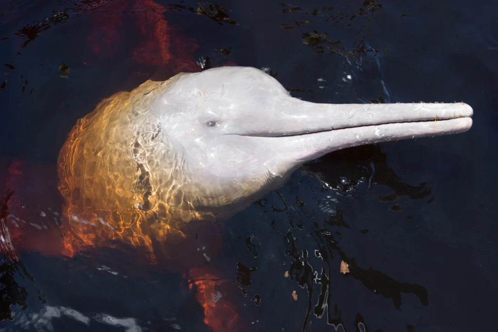
The Amazon River is an enormous aquatic ecosystem supporting thousands of species.
Wildlife associated with the river includes fish, reptiles, birds, mammals, amphibians, and countless smaller organisms.
Giant River Otters
Giant river otters are among the most charismatic mammals associated with Amazonian waterways.
They are highly social and spend much of their time swimming, fishing, grooming, and communicating.
Amazon River Dolphins
Amazonian rivers are also home to river dolphins, including the famous pink river dolphin.
Their coloration can become more pronounced with age, although individuals vary considerably in appearance.
Caiman
Caimans inhabit many Amazonian waterways.
They can often be observed near riverbanks, lagoons, and flooded forest environments, especially during nighttime wildlife excursions.
Fish
The Amazon aquatic ecosystem contains extraordinary fish diversity.
Examples include:
- Piranhas
- Arapaima
- Catfish
- Pacu
- Electric eels
- Tetras
- Stingrays
- Many other freshwater species
Some Amazon fish have developed remarkable adaptations to seasonal flooding.
What Is Unusual About the Amazon River?
Several characteristics make the Amazon particularly unusual.
It is both a river and a changing landscape
The Amazon cannot always be understood as a fixed blue line on a map.
Its water spreads into floodplains, channels, lakes, islands, and forests.
Its boundaries can change dramatically depending on water levels.
Its tributary network is enormous
The Amazon is fed by an extraordinary number of tributaries.
Each tributary creates its own ecosystem and connects different geographic regions.
It transports enormous quantities of freshwater
The Amazon’s discharge is one of its defining characteristics.
The amount of freshwater reaching the Atlantic is so great that the river influences coastal and oceanic conditions far beyond its immediate channel.
It can influence the Atlantic Ocean
Freshwater flowing from the Amazon carries sediments and dissolved materials into the Atlantic.
The influence of the river can extend well beyond the visible river mouth.
Why Is the Amazon Considered the Largest River in the World?
The phrase “largest river in the world” needs clarification because “largest” can refer to different measurements.
The Amazon is unquestionably the world’s largest river by average discharge, meaning the amount of water it releases toward the ocean.
It also has the world’s largest river basin by area.
However, largest by discharge is different from longest by distance.
Amazon River: Largest vs. Longest
| Measurement | Amazon River |
|---|---|
| Water discharge | World’s largest |
| Drainage basin | World’s largest |
| River length | Subject to measurement debate |
| Source | Multiple disputed headwaters |
| Main countries | Peru, Colombia, Brazil |
| Ocean destination | Atlantic Ocean |
This distinction helps explain why the Amazon can be called the world’s largest river while the question of the world’s longest river remains more complicated.
Amazon River Activities and Experiences
The Amazon River is not only important geographically; it is also central to rainforest travel.
Visitors can experience the river through:
- Riverboat excursions
- Canoeing
- Wildlife observation
- Fishing
- Sunrise trips
- Sunset excursions
- Night caiman searches
- Birdwatching
- Photography
- Visits to oxbow lakes
- Multi-day rainforest expeditions
River Wildlife Watching
Traveling quietly along the river provides opportunities to observe animals along the banks.
Capybaras may rest near water.
Birds can hunt along the shoreline.
Monkeys may appear in trees.
Caimans can be observed after dark.
Giant river otters may be encountered around productive lakes and waterways.
Amazon River Fishing
Fishing is an important recreational and cultural activity in many Amazonian regions.
Depending on location and regulations, visitors may fish for species such as piranhas, pacu, catfish, and other freshwater fish.
Fishing also provides an opportunity to understand how closely Amazonian communities are connected with the river.
Visiting the Amazon River
Travelers can experience the Amazon through different destinations and styles of travel.
In Peru, Puerto Maldonado and the Tambopata region provide access to rainforest environments where river transportation is often part of the journey.
A typical rainforest experience may involve traveling from the city by boat, reaching a jungle lodge, and then exploring nearby forests, lakes, rivers, and trails.
Best Experiences for First-Time Visitors
For a first Amazon trip, combining several environments provides a more complete experience.
A good itinerary can include:
- A river excursion
- A rainforest hike
- An oxbow lake
- A night wildlife excursion
- Monkey watching
- Birdwatching
- Caiman observation
- Fishing
- A sunrise excursion
The objective is not simply to travel along the river but to understand how the river and rainforest function together.
Final Thoughts About the Amazon River
The Amazon River is much more than a long river crossing South America. It is the central artery of an enormous freshwater system that connects the Andes with the Atlantic Ocean and supports one of the planet’s most biologically diverse environments.
Its exact length remains a subject of geographic discussion because identifying the most distant source is surprisingly difficult. Its source lies within the Peruvian Andes, while the main river travels through Peru, Colombia, and Brazil before reaching the Atlantic.
Its width and depth change according to geography and seasonal water levels, while annual flooding transforms surrounding forests into temporary aquatic environments. Its immense discharge and drainage basin explain why the Amazon is considered the largest river in the world by water volume, even though the question of whether it is also the longest river requires a more complicated discussion.
Perhaps the most fascinating fact is that the enormous river seen in the lowlands is the final expression of a vast network that begins with small mountain waterways. From tiny Andean streams to an immense tropical river carrying extraordinary volumes of freshwater into the Atlantic, the Amazon demonstrates how thousands of waterways can become one of Earth’s greatest natural systems.
For travelers, the river is also an entry point into the Amazon rainforest. Boat trips, wildlife watching, fishing, lake excursions, rainforest walks, and nighttime exploration allow visitors to experience the connection between water and forest firsthand.
The Amazon is therefore best understood not as a single line on a map, but as a constantly moving network of rivers, tributaries, floodplains, forests, wetlands, islands, wildlife, and human communities—a living geographic system whose scale is difficult to appreciate until you see it yourself.
:::