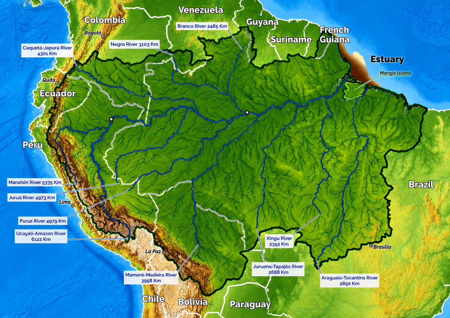
The Amazon Basin location covers one of the largest and most geographically important regions on Earth, stretching across much of northern South America and extending through several countries. Centered on the Amazon River and its enormous network of tributaries, the basin includes vast tropical forests, wetlands, floodplains, mountains, rivers, cities, farms, and Indigenous territories.
Understanding the Amazon Basin location is about more than finding the Amazon rainforest on a map. The basin is a huge drainage system shaped by rivers and topography, while the rainforest is the vegetation that occupies much of that landscape. Together, they form one of the most extraordinary geographic regions in the world.
This guide explains the Amazon Basin map, its area, countries, latitude, climate, population, agriculture, temperature, and geographical extent. It also explores what makes the basin unusual and why its location is so important to South America and the wider world.
Where Is the Amazon Basin Located?
The Amazon Basin is located primarily in South America, extending across a large portion of the continent north and east of the Andes Mountains. Its drainage area is centered on the Amazon River, which flows generally eastward across Brazil before reaching the Atlantic Ocean.
The Amazon Basin in South America occupies a broad lowland region between the Andes to the west and the Atlantic Ocean to the east. It extends northward toward the Guiana Shield and southward toward the Brazilian Highlands, creating an enormous natural drainage system.
Describe the Location of the Amazon Basin
To describe the location of the Amazon Basin, the simplest explanation is that it occupies the drainage area of the Amazon River and its tributaries. The basin begins in the highlands and mountains of western South America, particularly around the eastern slopes of the Andes, and gradually descends toward the Atlantic.
Unlike a political region with clearly visible borders, the basin is defined primarily by geography. Rainfall falling inside the basin generally drains through rivers and streams that eventually connect with the Amazon River system.
Geographical Location of the Amazon River Basin
The geographical location of the Amazon River Basin is determined by its watershed. Major tributaries such as the Rio Negro, Madeira, Tapajós, Xingu, Purus, Juruá, and Japurá contribute enormous quantities of water to the Amazon system.
The Andes play a particularly important role because they form the western boundary of much of the basin. From these high elevations, rivers descend toward the immense Amazon lowlands before eventually flowing toward the Atlantic Ocean.
Amazon Basin Location Latitude
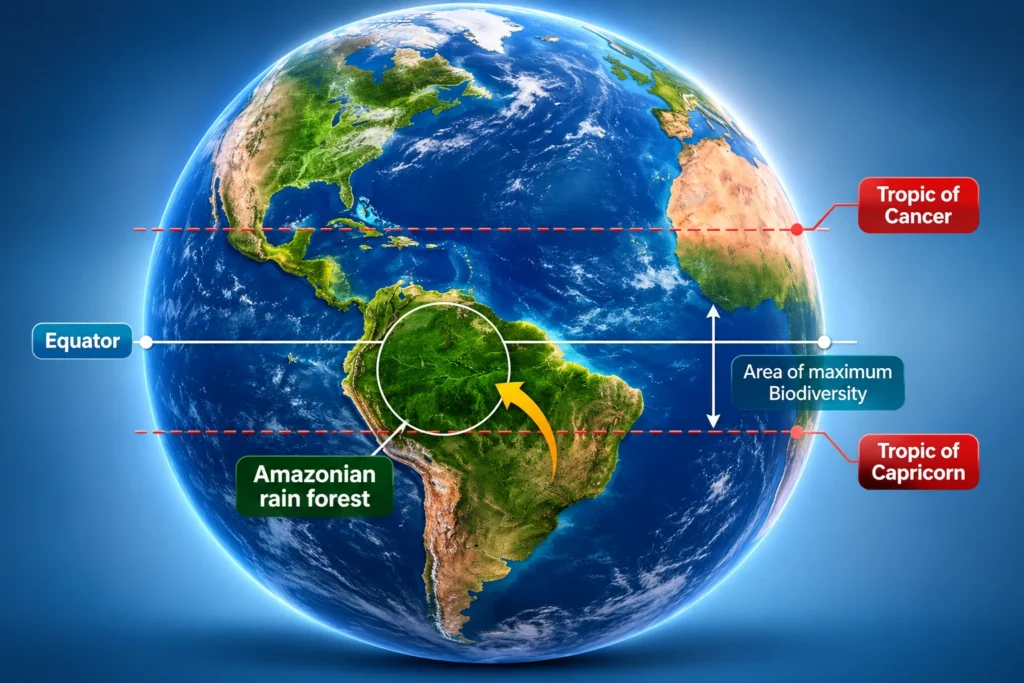
The Amazon Basin location latitude extends roughly from the equatorial region into the tropical latitudes of northern and central South America. The Equator crosses the northern portion of the basin, making its position especially important for understanding its warm and humid climate.
Because the basin stretches over such a large area, its latitude varies considerably from one location to another. Western parts near the Andes differ geographically from eastern areas near the Atlantic, even though both belong to the same enormous drainage system.
Amazon Basin Map and Geographic Extent
An Amazon Basin map provides one of the easiest ways to understand the enormous scale of this region. On a continental map, the basin appears as a vast area occupying much of northern South America.
The basin is often represented as a large drainage zone surrounding the Amazon River and its tributaries. Its boundaries are not identical to the boundaries of the Amazon rainforest, although the two areas overlap extensively.
Amazon Basin Location on Map
When viewing the Amazon Basin location on a map, look for the broad lowland area extending eastward from the Andes. The Amazon River forms the central drainage corridor, while thousands of tributaries branch throughout the surrounding landscape.
A physical map is especially useful because it reveals the relationship between mountains, plateaus, rivers, floodplains, and lowlands. The basin becomes easier to understand when viewed as a huge bowl-like drainage system rather than simply a forested area.
Amazon Basin Location on World Map
The Amazon Basin location on a world map places it in the northern half of South America, close to the Equator. Its enormous size makes it one of the most recognizable geographic regions on a global map.
The basin occupies a substantial portion of the continent, but it does not cover all of South America. The Andes, southern Brazilian highlands, Atlantic coastal regions, and other watersheds lie outside portions of its drainage area.
Amazon River Basin Location Map
An Amazon River Basin location map normally highlights the main river and its tributaries, along with the watershed boundary. This is useful because the basin is much larger than the visible channel of the Amazon River itself.
The river network resembles a giant branching tree. Smaller streams join larger tributaries, which eventually connect with the main Amazon system. This interconnected network is one of the defining geographic characteristics of the basin.
What Would an Amazon Basin Location Picture Show?
An Amazon Basin location picture can look very different depending on the scale. A satellite-style image may show an immense green region crossed by winding rivers, while a physical map may emphasize elevation and drainage patterns.
A useful location picture should ideally show:
- The Andes Mountains to the west
- The Amazon River and major tributaries
- The Atlantic Ocean to the east
- Major surrounding highlands
- National boundaries
- The approximate basin boundary
- Major cities and settlements
- Areas of rainforest, wetlands, and agricultural land
How Large Is the Amazon Basin?
The Amazon Basin area is commonly estimated at approximately 6 to 7 million square kilometers, depending on how the watershed is defined and measured. This makes it one of the largest river basins on Earth.
The enormous size of the basin is easier to appreciate by comparing it with countries and continents. It extends across a region larger than many individual nations and contains landscapes ranging from high mountain valleys to extremely low-lying floodplains.
Amazon Basin Area and Scale
The exact Amazon Basin area can vary between geographic references because watershed boundaries are not always represented identically. Some measurements use a narrower hydrological definition, while others include broader areas associated with the Amazon drainage system.
Regardless of the exact measurement, the basin is unquestionably enormous. Its scale influences rainfall, river discharge, ecosystems, transportation, agriculture, settlements, and regional climate.
Why Is the Amazon Basin So Large?
The basin developed around a massive drainage system that collects water from an extensive area. The Andes supply many major rivers from the west, while numerous rivers and streams from the north and south converge toward the central Amazon lowlands.
The relatively low elevation of much of the central and eastern basin allows rivers to spread across broad floodplains. During periods of high water, these landscapes can become temporarily inundated, creating complex seasonal ecosystems.
Which Countries Are in the Amazon Basin?
The Amazon Basin countries include several South American nations. The basin crosses national borders because its geographical boundaries are determined by watersheds rather than political boundaries.
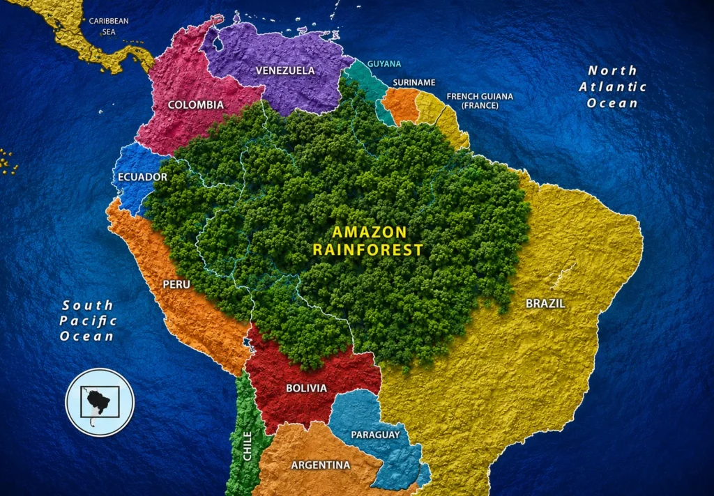
The countries commonly associated with the Amazon Basin include:
- Brazil
- Peru
- Colombia
- Bolivia
- Ecuador
- Venezuela
- Guyana
- Suriname
- French Guiana
Brazil contains the largest portion of the basin, while Peru contains a particularly important western section where many major tributaries originate or pass through the Amazon lowlands.
Brazil and the Amazon Basin
Brazil contains the largest share of the Amazon Basin and much of the central and eastern drainage system. The Amazon River crosses a vast portion of northern Brazil before reaching the Atlantic.
Major Amazonian cities and transportation routes are connected to this enormous river network, making rivers an important part of life in many communities.
Peru and the Amazon Basin
Peru occupies a crucial western section of the basin, where the Andes descend toward the Amazon lowlands. Rivers such as the Marañón and Ucayali form important components of the Amazon drainage network.
The Peruvian Amazon is also geographically diverse, including mountain foothills, lowland rainforest, oxbow lakes, wetlands, and extensive river systems.
Other Amazon Basin Countries
Colombia, Bolivia, Ecuador, Venezuela, Guyana, Suriname, and French Guiana each contain portions of the wider Amazon drainage region. Their landscapes vary significantly, from mountainous areas to lowland forests and wetlands.
This international character makes the Amazon Basin a geographical system shared by multiple countries rather than a single-country ecosystem.
Amazon Basin Location and Climate
The Amazon Basin location and climate are closely connected. Much of the basin lies in and around the Equatorial region, where intense solar energy, warm temperatures, and abundant moisture support a predominantly tropical environment.
However, the basin does not have exactly the same climate everywhere. Elevation, latitude, distance from the Andes, seasonal rainfall, river systems, and regional atmospheric circulation all influence local conditions.
Amazon Basin Temperature
The Amazon Basin temperature is generally warm throughout the year, particularly in the lowlands. Many lowland areas experience average temperatures around the mid-20s Celsius, although daily and seasonal conditions vary.
Higher elevations near the Andes can be considerably cooler than the lowlands. This means that the phrase “Amazon climate” describes a broad range of environments rather than one uniform temperature.
Rainfall and Humidity
Rainfall is one of the defining features of the basin. Warm air, abundant vegetation, rivers, lakes, and wetlands contribute to a humid environment where large quantities of water circulate between land, rivers, and atmosphere.
Some parts of the western Amazon receive extremely high rainfall, while areas farther south and east can experience stronger seasonal differences.
Wet and Dry Seasons
Many parts of the Amazon Basin experience seasonal variations in rainfall. During wetter periods, rivers rise, floodplains expand, and aquatic habitats become much more extensive.
During drier periods, river levels can fall significantly, exposing beaches and riverbanks. These seasonal changes strongly influence transportation, fishing, agriculture, wildlife behavior, and daily life.
Amazon Basin Population and Human Settlement
The Amazon Basin population is difficult to define with a single number because the basin crosses several countries and includes large cities, rural communities, Indigenous territories, and sparsely populated forest regions.
Although the basin is often imagined as an almost completely uninhabited wilderness, millions of people live throughout the wider Amazon region.
Life in the Amazon Basin Location
Life in the Amazon Basin location varies enormously. People live in major cities, small river communities, agricultural settlements, Indigenous territories, and remote forest villages.
For many river communities, waterways are central to daily life. Rivers can serve as transportation routes, fishing grounds, sources of food, and connections between communities.
Cities and Urban Areas
The Amazon Basin contains important urban centers, including cities such as Manaus, Iquitos, Santarém, Belém, and numerous smaller regional towns.
Urban areas can appear surprisingly large within the surrounding rainforest. Manaus, for example, is a major city situated deep within the Amazon region and connected to a huge network of rivers.
Indigenous Peoples
The Amazon Basin is home to hundreds of Indigenous peoples with diverse languages, traditions, histories, and relationships with the environment.
Many Indigenous communities have developed sophisticated knowledge of forests, rivers, plants, animals, seasonal changes, and local landscapes. Their presence is an essential part of understanding the human geography of the basin.
Amazon Basin Agriculture
Amazon Basin agriculture includes traditional subsistence farming, small-scale cultivation, cattle ranching, commercial agriculture, agroforestry, and other land-use systems.
Agriculture is not distributed evenly. Some areas have long-established farming communities, while others remain dominated by forests, wetlands, or protected territories.
Traditional Agriculture
Traditional agricultural systems may include crops such as cassava, maize, bananas, plantains, fruits, beans, and other locally adapted plants.
Small farms can be closely connected to seasonal rainfall and river cycles. In floodplain environments, farmers may adapt cultivation practices to changing water levels.
Commercial Agriculture
Commercial agriculture has become an important land-use activity in parts of the wider Amazon region. Cattle production and crops such as soybeans are particularly significant in areas where forests have been converted to agricultural landscapes.
However, agricultural expansion can create conflicts involving biodiversity, forest conservation, Indigenous territories, water resources, and land management.
Agroforestry and Sustainable Production
Agroforestry combines trees with crops or other agricultural activities and can provide an alternative to clearing large areas of forest.
Products such as açaí, Brazil nuts, cacao, coffee, fruits, and other forest-associated crops can support local economies while maintaining some tree cover when managed appropriately.
Amazon Basin Facts You Should Know
The Amazon Basin contains some of the most remarkable geographic features on the planet.
Key Amazon Basin Facts
- The basin covers roughly 6–7 million square kilometers, depending on the definition used.
- It extends across multiple South American countries.
- Brazil contains the largest portion of the basin.
- The Equator crosses the northern part of the basin.
- The Andes form an important western source region for Amazonian rivers.
- The Amazon River system contains thousands of tributaries.
- The basin eventually drains toward the Atlantic Ocean.
- Much of the lowland basin has a warm and humid tropical climate.
- Millions of people live within the wider Amazon region.
- The basin contains enormous areas of rainforest, wetlands, rivers, and floodplains.
- Seasonal river flooding creates temporary aquatic habitats across extensive areas.
- The region contains extraordinary biological diversity.
What Is Unusual About the Amazon Basin?
One of the most unusual things about the Amazon Basin is its sheer geographical complexity. It is not simply a forest surrounding one river. It is a giant interconnected system containing mountains, lowlands, rivers, lakes, wetlands, islands, floodplains, forests, cities, farms, and communities.
A River System Larger Than It Looks on a Map
The main Amazon River is only one part of the system. Thousands of tributaries contribute water to the basin, creating a network that reaches deep into remote regions.
Some tributaries are so large that they resemble independent rivers rather than branches of a larger system.
The Meeting of Waters
Near Manaus, two major rivers with visibly different water characteristics flow alongside each other before their waters fully mix. The phenomenon is known as the Meeting of Waters and is one of the most recognizable geographic spectacles of the Amazon region.
Rivers Can Become Highways
In many parts of the basin, roads are limited or difficult to construct. Rivers therefore become natural transportation corridors.
Boats can connect communities separated by dense forest, making the river network a vital part of the regional transportation system.
Forest and River Are Closely Connected
The Amazon forest and its rivers cannot be considered completely separate environments. Seasonal flooding carries nutrients, creates aquatic habitats, influences fish populations, and affects vegetation.
Some forests are adapted specifically to periodic flooding and can remain underwater for weeks or months depending on location and river conditions.
The Amazon Basin Today
The Amazon Basin continues to change as population growth, infrastructure development, agriculture, mining, conservation, climate variability, and urban expansion influence different parts of the region.
Current conditions vary significantly from country to country and from one part of the basin to another. Some landscapes are highly protected, while others experience substantial land-use pressure.
Deforestation and Land-Use Change
Forest loss remains one of the major environmental concerns associated with the Amazon region. Roads, agricultural expansion, cattle production, fires, mining, and other activities can transform forest landscapes.
At the same time, conservation initiatives, Indigenous land management, protected areas, restoration projects, and sustainable production programs are increasingly important components of Amazonian land management.
Changing Climate Conditions
Climate change adds another layer of complexity. Changes in rainfall patterns, temperature, drought frequency, river levels, and extreme weather can affect forests, wildlife, agriculture, transportation, and communities.
The enormous size of the Amazon means that climate conditions can differ dramatically between western, central, and eastern areas.
Why the Amazon Basin Location Matters
The Amazon Basin location is important because its geography connects mountains, forests, rivers, wetlands, agriculture, cities, and the Atlantic Ocean into a single enormous natural system.
Its position around the Equator contributes to high solar energy and warm temperatures, while the Andes provide water and sediments to western tributaries. The basin’s lowlands then channel enormous quantities of water eastward toward the Atlantic.
The region also plays an important role in the movement of water through the atmosphere. Forest vegetation releases moisture into the air through evapotranspiration, contributing to atmospheric moisture transport across South America.
Amazon Basin Geographic Extent: A Simple Summary
To describe the location and extent of the Amazon Basin in simple terms, imagine a gigantic geographic bowl occupying much of northern South America.
Its western edge is strongly influenced by the Andes. Its eastern drainage ultimately reaches the Atlantic Ocean. The northern and southern boundaries are shaped by surrounding highlands and watersheds.
Inside this enormous area are the Amazon River, thousands of tributaries, tropical forests, wetlands, floodplains, agricultural areas, cities, villages, Indigenous territories, and diverse ecosystems.
Amazon Basin Location at a Glance
| Geographic Feature | Description |
|---|---|
| Continent | South America |
| Main river | Amazon River |
| Approximate basin area | About 6–7 million km² |
| General latitude | Tropical and Equatorial South America |
| Western boundary | Andes Mountains and associated highlands |
| Eastern drainage | Atlantic Ocean |
| Largest country share | Brazil |
| Major ecosystem | Tropical rainforest and associated wetlands |
| Climate | Predominantly tropical, warm and humid |
| Population | Millions across the wider basin |
| Major geographical feature | Enormous interconnected river system |
Final Thoughts on the Amazon Basin Location
The Amazon Basin location represents one of the world’s largest and most complex geographical systems. Its importance comes not only from the rainforest but from the enormous network of rivers, mountains, wetlands, floodplains, agricultural landscapes, cities, and communities that occupy the basin.
Looking at an Amazon Basin map makes its size immediately impressive, but understanding its geography reveals even more. The basin stretches from the Andes across vast lowlands toward the Atlantic, crossing several countries and supporting millions of people.
Its area, location, latitude, climate, population, agriculture, and river network are all interconnected. The Equatorial position helps create warm conditions and abundant rainfall; the Andes feed major tributaries; the lowlands allow rivers to spread across enormous floodplains; and the forest interacts continuously with the atmosphere and waterways.
Perhaps the most fascinating fact is that the Amazon Basin is not one single landscape. It is a living geographic mosaic. Mountain forests, lowland rainforest, seasonally flooded forests, enormous rivers, wetlands, agricultural areas, urban centers, and Indigenous territories all form part of the same immense drainage system.
For anyone studying the geography of South America, the Amazon River Basin location map provides an excellent starting point. Once the relationship between the Andes, Amazon River, tributaries, lowlands, and Atlantic Ocean becomes clear, the extraordinary scale and importance of the Amazon Basin are much easier to understand.