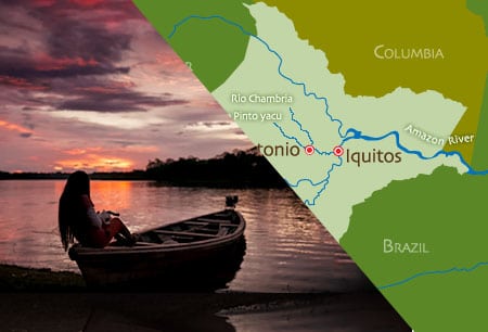
Iquitos Map and Location
The province of Maynas is located in the Loreto Region in the Northeast of Peru. The capital is the city of Iquitos that is located on the left bank of the Amazon River, it is the most important populated center in the Peruvian Amazon and it is the sixth most populated city in the country with 539,000 inhabitants approx. that lives on in an area of 119,859.40 km². It is one of the most important fluvial ports in South America along the Amazon.
The location of Iquitos is located at an approximate distance of 3,362 km from the mouth of the Amazon in the Atlantic Ocean and at 128 km. downstream from the confluence of the Ucayali and Marañón rivers, where the channel takes the name of Amazonas and more than 3000 km from what is said is the origin located in the Arequipa region, in southern Peru.
The province of Maynas borders Colombia to the north, the province of Mariscal Ramón Castilla to the east, the province of Requena to the south and the province of Loreto and Ecuador to the west.
Coordinates 3 ° 45 ‘0 “S, 73 ° 15’ 0” W
• Latitude: 03º 45 ‘S
• Longitude: 73º 14 ‘W
• Altitude: 96 m.s.n.m.
The metropolitan area of Iquitos is within 4 districts of the province of Maynas: Iquitos (173,584 inhabitants), Belén (84,531 inhabitants), Punchana (95,199 inhabitants) and San Juan Bautista (154,123 inhabitants) approximately.
Weather
Iquitos has a tropical rainy climate (hot and humid), with temperatures ranging from 19 ° C (66 ° F) to 37 ° C (99 ° F). The average annual temperature of Iquitos is 28 ° C (82.2 ° F), with an average relative humidity of 86{c0703f7f9c2066f1973534d24c719b55597fc2c19666777f4898692757df1612}. The rainy season is from November to April, with the fluvial network at its highest point in April and its lowest level in September, a season in which the tropical Amazonian beaches appear, cause of hullabaloo among the inhabitants of Iquitos and visitors.